Your guide
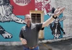
Clay Motley
Community partner in Clarksdale. Everything you hear is his voice,
recorded in the car with friends asking questions — not re-recorded, not cleaned up.
Clay has been coming to Clarksdale for twenty years. On this recording he is driving, pointing things out as they go past, and he says at the start that he is not going to act like a narrator.
What he keeps returning to is not what happened in a place, but who decided it mattered — and who paid to say so.
Same thirteen stops. Same thirteen minutes of Clay. Completely different to be inside of.

Thirteen places, thirteen worlds. Each stop is its own environment, and it moves on its own — Clay talks, and the photographs arrive around you, timed to his voice. At the stops where nothing was ever photographed, nothing comes, and you stand in the empty place for as long as he speaks.

All thirteen stops around one place, in the order Clay drove them — turning steadily right walks the whole tour. Open any stop, read the full record, and enlarge the photographs to archive resolution. Compass, map and a searchable list, so you can go straight to what you want.
Alongside Clay is the photographic record the federal government made of these same streets, mostly in 1939. Where a photograph exists, you can see it. Where none was ever made, this says so.
Five of the thirteen stops show nothing at all. That is not an oversight. The Farm Security Administration sent photographers across the rural United States to document the conditions its farm programmes were meant to address — which is why Clarksdale's cotton fields, juke joints and Saturday streets are so thoroughly photographed, and why its Black hospital, its bombed drugstore and its train station are not.
So the unevenness is the argument. A crossroads built by an industrial arts teacher in the 1990s has a marker and a photograph. Aaron Henry's drugstore, bombed by white supremacists, has neither.